
Beneath the Datum, Our Operations
Emergent grounds in the age of territorial displacement | Type: Research, speculation. Year: 2016.
Project extends the emerging connotations of geography as a constructed resource for urban managerial paradigms, to frame a possibility to pose such scenarios as potential architectural problems, with an underlying aspiration to restore the architectural intellect’s relevance to city-making. A narrative constructed out of an analysis of the linkages between corporate architecture, jurisdictional realities, and morphological principles of St. Louis, concludes with a proposal for a hybrid data-farming operation.

Western edge of St. Louis county, where risk management and production of urban space collapse into one.
In 2004, construction of the Howard Bend levee was completed, financed by a private group, converting a previous flood plain into a carved out slab of land ripe for development, within the city limits of Maryland Heights, on the western edge of St. Louis County. A comprehensive planning strategy adopted by the city council of Maryland Heights in 2007 followed, assigning mostly uniform light industrial use to the area, albeit consciously assuming an abstracted approach and language in doing so. Although the great recession of 2008 halted any prospect of development in the area till today, these series of bureaucratic acts of alignment that led to the collective project that is the Howard Bend planning district, presents an axiomatic back-story to build on; one that includes a private entity financing a –theoretically- public infrastructure, under the federal supervision of FEMA and US Army Corps of Engineers, to convince a city council to adopt a long term planning commitment whilst remaining dedicated to preserving public interests within such a framework. Consequently, construction of the levee as an artificial land operation, along with constructed floodways that act as inscriptions that increase the tolerance of the land in the face of flood from within, in a territorial scale, could also be read as spatial maneuvers necessitated by the will to sustain and nurture the urban condition and a capacity to accommodate the continuous external flows of the capital, eventually participating in the fabrication of geographical hierarchies. Within this context, geography could still be described as the accumulation of sets of regional physical qualifications that could be read as a local asset in regards to the extent and nature of operational responses allowed in relation to; but conceptually it’s not a primordial found-object anymore – it’s subject to constant fabrication, it’s more about a scalar mindset than enigmatic natural phenomena predating the act of settlement.
Zonal definitions of St. Louis and exclusive geographies of urban flows.
Institutional contingencies of land management practices on the Western edge of St. Louis county.
With this notion of geography-as-constructed-resource in mind, the project speculates an alternate narrative for the site. Locally headquartered global biotech company Monsanto’s institutional movement across the St. Louis fabric over the past hundred years, stretching from East St. Louis, IL to Chesterfield, MO on the western edge of the peninsula, paralleled by the company’s episodic operational evolutions, from producing saccharine, to agricultural chemicals, to the emerging interest in data management and precision agriculture practices, provides an apt case study to extend and investigate how an architectural project can situate itself between corporate endeavors and production of urban space. Feeding off from emerging connotations of logistics surrounding precision agriculture, that utilize big-data applications to manage farming decisions made on the field, a praxis involving novel conceptions of spatial disposition through examples such as one acre of farmland producing 7 gigabytes of data per day that occupies roughly .003% of a typical server rack that has to be accommodated within a greater facility supported by urban infrastructure and spatial protocols, the project eventually proposes rethinking the traditional data-center typology, stemming from a reading of its infrastructural dependencies to external sources and conceptual relevance to everyday life as potential leads; the main objective in this typological inquiry being the ability to pose the architectural project as construction of sites that could be acted upon and in reference to, as an open ended and indexical alternate to end-product oriented mindset of the masterplan. Can the practice of architecture establish a newfound relevance to the construction of the experience and form of the urban condition, through assuming a mediating role in the midst of capital, logistical, or even quotidian interests – bringing forth new adjacencies and displaying the possibility of new forms of institutional alliances? In other terms, the property line and the setback – the two main abstract spatial elements of separation that precondition the contemporary urban realm – are inherently institutional thresholds, hence a provocation that renders the property line and the setback as a part of the architectural act rather than accepted prescriptive frames requires a conscious commentary on the nature of institutional relationships governing –or necessitate- them in the first place.
Relational consequences and spatial dispositions of emerging big-data practices.
With a core concern of situating critical architectural thought within a participatory practice with other forces that take part in construction of the aforementioned understanding of geographical scale as a fabricated reality, investigated typology aspires to defy the scalar thresholds between architecture, landscape, and the urban. For the program, the developed scheme projects a coexistence of data-farming, a water purification cycle, greenhouses, and an overall topography that acts as a drainage topology for the surrounding locality. Tectonically, the water cycle that occupies the lowest level provides a foundational grid of retaining walls upon which data vaults rest, while processed and stored water in intermediary basins is used in a radiant cooling cycle within the concrete envelope that encloses the vaults. Heat is exchanged through this radiant ceiling, with series of sectional conductive processes, to a heat sink composed of a greater basin held within a bounding slab, which could either be treated as a heat source for future adjacent developments or simply as a heated super-surface upon which retractable-roof greenhouse operations could take place, propagating a cultivation terrain within the urban sea. Sectional relationship between data vaults and water cycle allows chambers to be partially submerged in water in-process of being treated, providing another source of insulation, while partial exposure of post-process water becomes a design and boundary element for exterior landscapes. The topology that wraps the typical site is designed to channel rainwater to drainage basins on shorter edges, with the goal of rendering the site itself as an initial drainage system for future adjacent developments. With the existing clause of zoning code projected by the city council -concerning the storm-water collection system in the area- in mind, these sites would exist in between other shared primary storm-water collection channels, planned to be dispersed linearly every 1600 ft across the zoned area. In touch with the pre-projected logics of zonal subdivision, yet acting as a crystallization of sorts for such, the typology is imagined as a conduit, or formally akin to an island with strategic perforations, charged with an intrinsic self-referential capacity, yet mindful of the sea it exists within and produces difference in relation to. Consequently through arranging a utility belt axis, a logistical edge, a heated edge that could be appropriated accordingly, and projected public space manifested through various spatial typologies within, the complex could potentially introduce a differential parameter within a fabric. The scope of the project was limited to the question of discovering what the architecture of this indexical mindset could be.


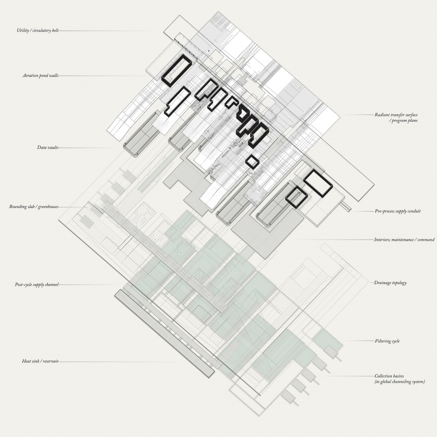


Idea of containment eventually becomes important in a fourfold way, as in containment of servers in vaults; of water in series of retaining ponds that vary in scale according to operation; of heat and vegetation in operations relating to the heat sink and greenhouses, and of the rainwater through the constructed landscapes and basins. The project, in essence, is about a choreography of interrelated acts of containment as a space making strategy, that collectively construct a specific site through the management of relationships. Although it is a conscious goal to create spaces that remain open ended, ambiguous, indeterminate, defined as a field of limitations to be appropriated by future use above the ground, the overall image of the project is one of a highly disciplined and interconnected sets of operations underground. In the end, it is a project about finitude, and posing the earthly necessity and reality of finitude as a design question in the face of ever effervescent all-inclusive systems. It’s about increasingly problematic yet easily ignored sheer physicality, stubbornly multiple yet finite, in the face of conceptions of intangibility and spatial dispositions. Just as it is a proposition in posing the construction of the datum, the preconditioning of the urban, as an architectural problem, the project is not a mere championing of systems over objects, or vice versa; it’s a call for design to occupy the agonistic space in between the parts and the whole.


Project: Aykut Imer.